Friday, December 25, 2009

TROPICAL CYCLONE MICK

We began watching Tropical Cyclone Mick on the 14th of December. By that time it was already a category 2 storm and was bearing down on Fiji. It is the first cyclone of the storm season.

It is extremely difficult to measure the strength, wind speeds, and pressures of cyclones in the middle of the Pacific. Weather monitoring stations are few and far between, and we don't have "storm tracker planes." Satellites can track them, but that only provides a historical picture of the path it has taken.

My experience with gulf coast hurricanes has been helpful, but I’ve had to learn to think in reverse. Tropical storms in the South Pacific turn in a clockwise direction (opposite from the northern hemisphere). That means the wet or dirty side of the storm is on the left side, not the right. However, I’ve been able to use a combination of tools to provide some elementary storm path predictions. Such was the case with “Mick.” Each morning I would check its location and speed, then chart a path on Google Earth, to predict when and where it would be. Mick was uncommonly predictable in the path it followed, but caught everyone off guard in terms of timing and effect. Mick hid the coast of Fiji 6 hours ahead of all predictions, and instead of dumping a lot of rain as anticipated, the greatest damage was from the high winds.

Conversely, as Mick departed the main island of Viti Levu the greatest damage was from flooding on the small off-shore island of Mbengga, southwest of Suva.

Fiji is currently under the rule of the military – the result of a coup that took place three years ago. The Commodore has divided the country into four divisions. The Eastern Division suffered the most damage. The greatest lost overall however, was the lost of family gardens and root crops that were destroyed either by the high winds or the salt water coming ashore.

During a private meeting with the Fiji DMO Director, however, we were told that the cyclone was a blessing in disguise. The country has been in the middle of a serious drought, and the rain that the storm brought filled the hydroelectric plant reservoirs. Thus the money the government will not have to spend on diesel fuel for electricity will more than offset the damage caused by the storm. Therefore it is the individual subsistence farmers that will suffer the most.

The storm did claim the lives of two young victims, a teenager who was swept away by floodwaters and a boy who was killed by a falling tree in Savatu Village in Nadarivatu, while two others were swept away by flood waters.

We have been conducting daily conference calls with our local team, church leaders in Fiji, and our counterparts in Salt Lake City. Working with the Fiji DMO, we provided emergency relief supplies to the temporary shelters and also purchased chain saws for the government and community volunteers to use to facilitate the removal of debris. In addition we purchased water containers for one village that lost its source of clean water.

Local church members in the areas that were not affected also provided assistance to the impact areas. This assistance was mostly in the form of clothing drives and clean-up teams.

The lost of family gardens and small farms due to high winds and salt water will effect these people for many months.

Some of the “lost crops” can be salvaged for immediate use, but after that they will have to plant and then wait for the new crop.

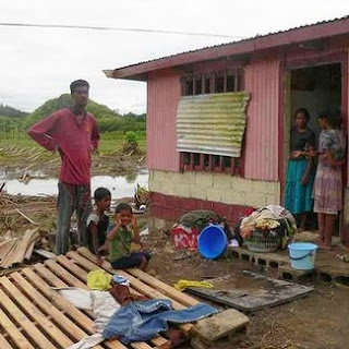
Low lying areas were flooded, higher areas were damaged by the winds. More than 4,000 people had to evacuate to temporary shelters until the flood waters subsided.

THE VANUATU VOLCANO

A couple of days after John and Shona came for their visit the volcano on a small island north of the main island of Espiritu Santo became very active. It had been smoking and threatening for quite some time, but now it began to spew mud and ash and caused the local rains to turn acidic.

We were able to get approval for an emergency relief project to help the villagers who had to be evacuated. The Vanuatu Disaster Management Office (DMO) decided that the villages in danger would have to be evacuated. Their plan was to have each relocated family hosted by another family on the opposite side of the island which shared the same ethnic and cultural beliefs. This “one family at a time” approach took a lot of extra effort, but it proved to be a very successful plan. Each evacuee family was matched up with a host family. The government then allocated additional land to the host family so they could plant more crops to support their family and the hosted evacuees. Detailed census information was collected for each host family and for each evacuee family. No one was lost or left out. All were accounted for and taken care of.

In addition to providing emergency relief food to assist in tiding them over until their new gardens can begin to produce, our emergency relief project also provided farm and gardening tools for the evacuees, and water storage tanks for the host villages. We have been conducting regular conference calls with our in-country contacts, church leaders, village leaders, and others to coordinate the needs and resources of the evacuees and the host families. The situation is beginning to stabilize now, so we won’t need to contact them again until next week.

This is a picture of the beautiful island of Gaua under normal conditions.

This is a picture taken by someone else of the Gaua Volcano as it started to increase in activity. (See credit of photo)

Here are the local members of the LDS Church who assisted us in distributing food and supplies to the evacuees.

This is a picture of our local relief workers with some of the evacuees.

More evacuees with their host families, some of whom were also LDS relief workers.

These are members of the LDS Church on the island of Gaua, Vanuatu.

These men are the priesthood leaders of the Gaua Branch of the LDS Church.

Here we are delivering a water storage tank to one of the host villages. With the additional village members (evacuees) they need to be able to capture and hold more rain water.

These are the village chiefs from both the east and the west sides of the island. They met to work out the evacuee/host-family details.

This is a picture of the headquarters for host-family coordination.

Here are some evacuees waiting to see an airplane land and take off. They don’t have a landing strip on their side of the island.

This is a picture of the Red Cross and Vanuatu Disaster Management Centre. We coordinated all of our relief work with this group.

Smoke and ash billowing from the volcano.

This is a picture of some volcanic ash that built up on a leaf.

Finally, a picture of the LDS Church branch president collecting census information from members of the church who were host families. The information he gathers is turned into the DMO.

Tuesday, December 15, 2009

WE'VE GOT MAIL - I MEAN, COMPANY!!

Yay, we were so excited to have John and Shona come to visit us! They were able to get away for a trip to New Zealand, which, of course, included the interminable hours both coming and going. Shona's sister Laura stayed with the kids so they could have this little get-away. Thanks, Laura!!

We kept on the go and showed them many of our favorite places. They were good sports and let us haul them up and down hills, through the bush, onto beaches and rocks, and endured several long car rides. John was our chef nearly every night and we enjoyed his making us stuff we were really hungry for!

We had our cameras at the ready and documented their visit on location.

On a bluff above the Taman Sea

On a volcanic hill across from the Auckland skyline

At a cave on the beach of the Auckland harbor

Inside a fortification on the coastline guarding the Auckland Harbor

Umm, not paying much attention to the view

or the Party Tree on the location of The Lord of the Rings set

The two little American Hobbits in the Hobbit Hole

The Sky Tower towering over them

In front of the New Zealand Temple in Hamilton


Did you see a pattern developing among this couple????


Sad to see them go, but we really enjoyed having them here and had a nice time with them. Hopefully it will be a trip they'll remember for a long time.

Saturday, November 21, 2009

Kiribati [KEER-uh-bass]

Strategic Kiribati. Situated in all four hemispheres (north and south of the equator; and east and west of the international date line), it is a unique place, but perhaps not quite ready for the front page of Vacation magazine.

Nevertheless my little point-and-shoot camera captured some of the most idyllic pictures you could ever dream of ...

White sandy beaches, with palm trees licking up the equatorial sun, and clear Pacific blue water ...

Native habitat made of local materials, traditional styles, and "home-spun" craftsmanship ...

Children and adults alike swim and bath in the crystal clear waters of a huge lagoon situated on an ancient coral reef.

Yet, Kiribati was the site of the bloodiest battle of World War II. And it has been trying to recover ever since. It is a "study" of the long-term cultural effects of government-style intervention with social programs.

Everywhere we went, everyone we spoke to, everything we saw, underscored the continuing need for more intervention, more foreign aid, or more social assistance programs. Yet, each look also revealed, with equally impressive evidence, a pattern of long term local neglect and abuse. Everywhere, we saw evidence of what used to be, or of what they once had; all of which was originally given as a free gift—a hand out—from some foriegn government or charitable organization. With sincere appreciation they willingly accept anything and everything someone is willing to give them, run it until it dies, then walk away and wait for someone else to either fix it or give them another one; never lifting a finger to help themselves, just patiently doing without until someone comes to their rescue.

So here I was combing the place, visiting with members of Parliament and other high ranking officials to try to determine what needs they had that we could assist with. Hmmm, and why would I want to do that? The answer: Because the LDS Church doesn’t offer just “free gifts” that perpetuate a “something-for-nothing” mentality, as you will see.

You may recall some pictures in an earlier blog of the hospital here. In fact you may remember this picture of a nursing unit utility room.

We've been working to get some projects organized that will help them now and in the long-term. Part of the purpose of this trip was to kick off a couple of these projects.

We had more than eighty people from the community show up the first day of our service project; and a like number everyday thereafter. We provided all of the supplies and materials; but they had to provide all of the labor and supervision (volunteers).

They worked twelve hours a day for six consecutive days to scrub, scrape, sand, and paint five hospital units (wards), inside and out.

Here are the before, during and after pictures of the medical ward.

This next picture is an after shot of the same utility room shown above.

It is our belief that by working for what they get, they will appreciate it more and will try a little bit harder to take care of it and keep it up -- and they will feel better about themselves. Hopefully, their improved self-esteem will spill over into other parts of their lives, and little by little they will begin to take responsibility for their own future.

Another of my purposes in going was to check out some clean water projects we have planned for several villages. These projects, too, will require the villagers to work for what they receive.

This picture is of a meeting we had with the village leaders in one of the communities we will be placing a rain water harvesting system. The meeting was conducted in a big hut called a “Maneaba.”

Every village in Kiribati has a Maneaba. They can be as much as 40 meters long. They are used for community meetings, social gatherings, youth activities, etc.

Even though it was very hot on the day we had our meeting, it was comfortable under the Maneaba. One of the men in the meeting gave us some coconuts to drink from. Mmmm, it was refreshing!

One day we went in a small boat to some of the other islands. They are just called the “outer islands.” Some of them don’t have names, but we went to one that was called Abaiang.

All went well until it started to storm. Then the sea got rough and we started to bounce around. So we had to slow down, and that took us a lot longer to get to Abaiang. I was really glad when we finally got there because I was starting to get a bit sea sick.

Almost all of the people live in houses that look like this one. The floor is built up off the ground, and the roof is made of thatched palm fronds. As in almost all of the islands, they sleep on mats that they weave from Pandanus leaves.

Some of the islands had a richer top soil which allowed grass to grow naturally. Others had the same sand and coral mix that was prevalent in Tarawa. None the less, we saw some very beautiful, well kept villages. I was most impressed with the outer islands.

Anyone who really knows me, knows how much l love little children. So, naturally, every island we went to I was able to gather a small crowd of children. In this picture, the children are holding Flat Stanley, who came to visit us from Florida.

Each time we left one of the outer islands the children came to the beach to wave good-bye to us. They are always happy to have visitors. Everyone was so gracious.

Everywhere we went the people apologized for not being prepared to feed us – “next time let us know when you are coming and we will prepare a feast.”

Back in Tarawa, Kitibati I enjoyed one last sunset outside my apartment door before returning to my sweetheart in New Zealand.

Saturday, November 14, 2009

FLAT-LANDERS AGAIN

After our last trek up the mountain, we opted for sea level this time. We have two new senior couples, fairly recently arrived from the States, who haven't seen much of New Zealand yet, and asked us to take them with us some time. The past two Saturdays we took one of the couples with us each time. Of the fifteen or so senior couples, we're the only ones who walk further than from the car to the elevator. But they both promised to keep up if we'd slow down a little for them. We had fun both times, and hopefully have introduced them to some of the great outdoor stuff here.

The weather is finally shaping up, most of the time. The UV levels here are really high, so it's time for me to begin covering up again. I don't like that part, but oh well! This picture was actually to show off the flowers growing on the cliff along the beach walk, not my sun wear!


In all the beach walks and tide pool searching we've done, this was the very first time we've ever come across a jelly fish. It was huge, pink, and transparent. No doubt at all why it's called a jelly fish! It must have been 18 or 20" in diameter. Later on we saw two more. Why now all of a sudden? They washed in at high tide and then got stranded on the rocks when the tide went out.


Most of our beaches here are NOT the tropical paradise kinda beaches you might see on travel folders. Lots of volcanic rock and stuff other than brown sugar sand. When the tide is out, we see all sorts of formations.

The crusties have attached themselves to all these rocks.

After we'd shown our friends this East Coast beach, we drove over to the wild West Coast of the Tasman Sea. The weather over there is always windier and the sea is wilder. This is the black sand beach we talked about several posts ago.

A sample of the wild Tasman sea, spraying up on the rocks where we were standing.

Coming back to Auckland, we saw this beautiful display of sun rays over the harbor,

and a dark, mean looking sky over the city.