Sunday, January 3, 2010

A New Year’s Eve Hike

Our offices closed at noon on New Year’s Eve, and the place quickly became a ghost town. We finally got our stuff to a stopping point about 12:30 p.m. and by then we were the only ones in the building. We headed quickly to our apartment, changed clothes, grabbed a bite to eat, loaded the car and were off to our predetermined destination – Matamata. When John and Shona were here last month, we saw a tall water falls from the highway in the distant mountains. We were fascinated, and decided to hike up to it. Upon getting to the location we learned that the falls was named Wairere, and has a drop of over 500 feet. At the bottom of the track a sign suggested that it would take us almost two hours to get to the falls, we were starting at 5:30 p.m. – hmmm.

Once inside the forest, the tall trees and thick tree ferns made the hike cool and pleasant and almost immediately dark in the late afternoon sun.

The track took us through a beautiful, diverse range of natural scenery that appeared to have hardly been touched by man.

In addition to the water falls, which was our original destination, there was a beautiful river which we followed up the mountain for several miles.

The path crossed several rivers and stream beds on its way up.

Along the path were several picturesque river falls and cascades.

It should be no surprise that some sections would include steep stairways or mountain paths. This particular section contained more than 200 steps.

The entire pathway meandered around and through a boulder strewn rain forest which reflected every color of green imaginable.

The light that came through breaks in the forest canopy reflected beautifully on the small ponds that we found from time to time along the river.

The falls was stunning, but the magnitude was almost in comprehensible. If we go close enough to photograph it all, it was so far away that the details were lost. Up close, only small sections could be seen at a time.

There are numerous pools to along the way, and several side tracks to be explored.

Racing the sun-dial, we took the time to explore only one side path. It lead us to a beautiful lush pasture land that overlooked a vista that the setting sun bathed in long shadows that accented the trees and farm lands far below.

Still racing the sun, we took only one short breather to grab a picture of the two of us together.

As the sun continued to fall we began to think that we might get caught in a dark forest. This was one that it would be safer to just stay the night than to try to navigate in the dark. (We picked up our pace – considerably)!

We emerged from the forest just in time to catch the sun setting behind the distant mountains on the other side of the valley.

As we drove away, the full moon poked its face above the very forest from which we had just emerged. What an exciting adventure and we were glad we didn’t have to stay in the forest the whole night.

A Boxing Day Tramp

Christmas in a foreign country, not to mention – in the middle of summer, and without family is pretty much a non-event. We were invited to our supervisor’s home for a Christmas brunch, and then spent most of the afternoon with several other senior missionaries who are here from various parts of the U.S. It was all pretty low key. The day after Christmas was spent at our apartment after doing some necessary chores. But… Tah dah … then came Boxing Day, a national holiday. After staying inside almost all of Christmas and the day after we were itching to get out and do something.

We drove to a large public forest (here it is called a range) about an hour from our apartment. We found a “track” that we hadn’t “tramped.” (A trail we hadn’t followed)

We started by crossing a long suspended swinging bridge that crossed a deep ravine with a small river running through it. Both sides of the ravine were covered with bushes, vines, ferns, and trees.

We’ve looked up at a lot of ferns and the beautiful silhouettes they make against the blue skies. But this was the first time we’ve actually been able to look right down into the center of one.

We didn’t go very far before we started to climb. Fortunately, most of the uphill paths had stair steps or we probably wouldn’t have made it to the top of the mountain. The trail consisted of one set of steps after another after another – always through a beautiful, lush, rain forest.

Once in a while the path would almost level out and we would be able to catch our breath before taking off again on another climb.

About half way up to the summit we were able to catch this vista of the farm lands below. What a beautiful countryside. What a beautiful country.

As with most of our adventures, I try to mix my appreciation of the wide open expanse (as above) with the local flora and fauna. But I also really enjoy getting on my knees and inspecting the small details and make it all alive.

This little puff was the head of a moss covering. The closer I got, the more details I could see. Each little leaflet was edged with fine cilia-like fuzz. It is so easy for me to become enchanted with these details.

Continuing my interest in the “details” I was able to capture on “film” several other unique plants with captivating growth patterns.

This particular leaf is a fern, but the intriguing things are the raised dots that run along both sides of each lobe of the leaf.

Here we have another fern. This is probably the most common fern we see here in New Zealand. It is called the Silver fern.

This is a picture of the underside of the leaf above. Now you can see why it is called the Silver Fern.

When Silver Ferns get old and dry up, they hang in some of the most interesting arrangements.

Our hike not only took us through the lush rain forests, but toward the top of the mountain we entered a section of tall, tall trees – but even they didn’t seem to inhibit the undergrowth too much.

Continuing my fascination with the finer details, I captured several forms of moss.

These little curly mosses were so soft and furry.

But others are prickly and spiny.

Diane thinks I get too involved in my picture taking. Here she caught me leaning against a tree to get just the right angle and lighting for something that captured my attention.

The trail eventually started downward. It is a lot easier going down using the steps. We aren’t as sure-footed as we once were.

High in the mountain tops we caught some wonderful vistas. Cloudy days in New Zealand are the norm. But that made for an absolutely wonderful hike. Not too hot, not too cold – just right – so we eat it all up.

Coming down a bit further our trail skirted this beautiful lake.

There were several ups, even when coming down. But mountain climbing is that way.

But we eventually arrived back to the road (gravel) where we parked our car.

But before going home we stopped in Pokeno for some Turkish pastry and ice cream.

A wonderful day! Happy Boxing Day!

Friday, December 25, 2009

TROPICAL CYCLONE MICK

We began watching Tropical Cyclone Mick on the 14th of December. By that time it was already a category 2 storm and was bearing down on Fiji. It is the first cyclone of the storm season.

It is extremely difficult to measure the strength, wind speeds, and pressures of cyclones in the middle of the Pacific. Weather monitoring stations are few and far between, and we don't have "storm tracker planes." Satellites can track them, but that only provides a historical picture of the path it has taken.

My experience with gulf coast hurricanes has been helpful, but I’ve had to learn to think in reverse. Tropical storms in the South Pacific turn in a clockwise direction (opposite from the northern hemisphere). That means the wet or dirty side of the storm is on the left side, not the right. However, I’ve been able to use a combination of tools to provide some elementary storm path predictions. Such was the case with “Mick.” Each morning I would check its location and speed, then chart a path on Google Earth, to predict when and where it would be. Mick was uncommonly predictable in the path it followed, but caught everyone off guard in terms of timing and effect. Mick hid the coast of Fiji 6 hours ahead of all predictions, and instead of dumping a lot of rain as anticipated, the greatest damage was from the high winds.

Conversely, as Mick departed the main island of Viti Levu the greatest damage was from flooding on the small off-shore island of Mbengga, southwest of Suva.

Fiji is currently under the rule of the military – the result of a coup that took place three years ago. The Commodore has divided the country into four divisions. The Eastern Division suffered the most damage. The greatest lost overall however, was the lost of family gardens and root crops that were destroyed either by the high winds or the salt water coming ashore.

During a private meeting with the Fiji DMO Director, however, we were told that the cyclone was a blessing in disguise. The country has been in the middle of a serious drought, and the rain that the storm brought filled the hydroelectric plant reservoirs. Thus the money the government will not have to spend on diesel fuel for electricity will more than offset the damage caused by the storm. Therefore it is the individual subsistence farmers that will suffer the most.

The storm did claim the lives of two young victims, a teenager who was swept away by floodwaters and a boy who was killed by a falling tree in Savatu Village in Nadarivatu, while two others were swept away by flood waters.

We have been conducting daily conference calls with our local team, church leaders in Fiji, and our counterparts in Salt Lake City. Working with the Fiji DMO, we provided emergency relief supplies to the temporary shelters and also purchased chain saws for the government and community volunteers to use to facilitate the removal of debris. In addition we purchased water containers for one village that lost its source of clean water.

Local church members in the areas that were not affected also provided assistance to the impact areas. This assistance was mostly in the form of clothing drives and clean-up teams.

The lost of family gardens and small farms due to high winds and salt water will effect these people for many months.

Some of the “lost crops” can be salvaged for immediate use, but after that they will have to plant and then wait for the new crop.
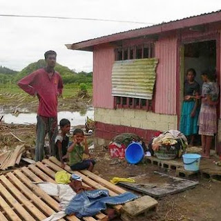
Low lying areas were flooded, higher areas were damaged by the winds. More than 4,000 people had to evacuate to temporary shelters until the flood waters subsided.

THE VANUATU VOLCANO

A couple of days after John and Shona came for their visit the volcano on a small island north of the main island of Espiritu Santo became very active. It had been smoking and threatening for quite some time, but now it began to spew mud and ash and caused the local rains to turn acidic.

We were able to get approval for an emergency relief project to help the villagers who had to be evacuated. The Vanuatu Disaster Management Office (DMO) decided that the villages in danger would have to be evacuated. Their plan was to have each relocated family hosted by another family on the opposite side of the island which shared the same ethnic and cultural beliefs. This “one family at a time” approach took a lot of extra effort, but it proved to be a very successful plan. Each evacuee family was matched up with a host family. The government then allocated additional land to the host family so they could plant more crops to support their family and the hosted evacuees. Detailed census information was collected for each host family and for each evacuee family. No one was lost or left out. All were accounted for and taken care of.

In addition to providing emergency relief food to assist in tiding them over until their new gardens can begin to produce, our emergency relief project also provided farm and gardening tools for the evacuees, and water storage tanks for the host villages. We have been conducting regular conference calls with our in-country contacts, church leaders, village leaders, and others to coordinate the needs and resources of the evacuees and the host families. The situation is beginning to stabilize now, so we won’t need to contact them again until next week.

This is a picture of the beautiful island of Gaua under normal conditions.

This is a picture taken by someone else of the Gaua Volcano as it started to increase in activity. (See credit of photo)

Here are the local members of the LDS Church who assisted us in distributing food and supplies to the evacuees.

This is a picture of our local relief workers with some of the evacuees.

More evacuees with their host families, some of whom were also LDS relief workers.

These are members of the LDS Church on the island of Gaua, Vanuatu.

These men are the priesthood leaders of the Gaua Branch of the LDS Church.

Here we are delivering a water storage tank to one of the host villages. With the additional village members (evacuees) they need to be able to capture and hold more rain water.

These are the village chiefs from both the east and the west sides of the island. They met to work out the evacuee/host-family details.

This is a picture of the headquarters for host-family coordination.

Here are some evacuees waiting to see an airplane land and take off. They don’t have a landing strip on their side of the island.

This is a picture of the Red Cross and Vanuatu Disaster Management Centre. We coordinated all of our relief work with this group.

Smoke and ash billowing from the volcano.

This is a picture of some volcanic ash that built up on a leaf.

Finally, a picture of the LDS Church branch president collecting census information from members of the church who were host families. The information he gathers is turned into the DMO.