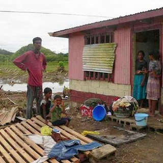
It is extremely difficult to measure the strength, wind speeds, and pressures of cyclones in the middle of the Pacific. Weather monitoring stations are few and far between, and we don't have "storm tracker planes." Satellites can track them, but that only provides a historical picture of the path it has taken.
My experience with gulf coast hurricanes has been helpful, but I’ve had to learn to think in reverse. Tropical storms in the South Pacific turn in a clockwise direction (opposite from the northern hemisphere). That means the wet or dirty side of the storm is on the left side, not the right. However, I’ve been able to use a combination of tools to provide some elementary storm path predictions. Such was the case with “Mick.” Each morning I would check its location and speed, then chart a path on Google Earth, to predict when and where it would be. Mick was uncommonly predictable in the path it followed, but caught everyone off guard in terms of timing and effect. Mick hid the coast of Fiji 6 hours ahead of all predictions, and instead of dumping a lot of rain as anticipated, the greatest damage was from the high winds.
Conversely, as Mick departed the main island of Viti Levu the greatest damage was from flooding on the small off-shore island of Mbengga, southwest of Suva.
Fiji is currently under the rule of the military – the result of a coup that took place three years ago. The Commodore has divided the country into four divisions. The Eastern Division suffered the most damage. The greatest lost overall however, was the lost of family gardens and root crops that were destroyed either by the high winds or the salt water coming ashore.
During a private meeting with the Fiji DMO Director, however, we were told that the cyclone was a blessing in disguise. The country has been in the middle of a serious drought, and the rain that the storm brought filled the hydroelectric plant reservoirs. Thus the money the government will not have to spend on diesel fuel for electricity will more than offset the damage caused by the storm. Therefore it is the individual subsistence farmers that will suffer the most.
The storm did claim the lives of two young victims, a teenager who was swept away by floodwaters and a boy who was killed by a falling tree in Savatu Village in Nadarivatu, while two others were swept away by flood waters.
We have been conducting daily conference calls with our local team, church leaders in Fiji, and our counterparts in Salt Lake City. Working with the Fiji DMO, we provided emergency relief supplies to the temporary shelters and also purchased chain saws for the government and community volunteers to use to facilitate the removal of debris. In addition we purchased water containers for one village that lost its source of clean water.
Local church members in the areas that were not affected also provided assistance to the impact areas. This assistance was mostly in the form of clothing drives and clean-up teams.
 The lost of family gardens and small farms due to high winds and salt water will effect these people for many months.
 Some of the “lost crops” can be salvaged for immediate use, but after that they will have to plant and then wait for the new crop.
 Low lying areas were flooded, higher areas were damaged by the winds. More than 4,000 people had to evacuate to temporary shelters until the flood waters subsided.


